-

- This reach contains hazards
-

- Always wear a life jacket and helmet and carry a first aid kit
-

- Check flow conditions
-

- The water is very cold and hypothermia can set in within minutes
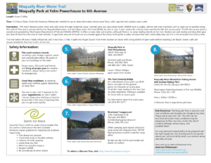
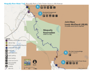
The Nisqually Park at Yelm Powerhouse to 6th Avenue reach is approximately 9 miles in length and can take between 4-6 hours. (Note: Check the American Whitewater website for up-to-date information about water flows, skills required and suitable water craft.)
This reach features scenic views and calm water through residential areas, forested areas and agricultural lands. Wildlife such as eagles, salmon and even sea lions can be spotted along this stretch. Because this area is surrounded by the Nisqually Reservation, Joint Base Lewis-McChord (JBLM) and private lands, be sure to stay in your watercraft until you have reached the 6th Avenue access point. The 6th Avenue access point is owned and operated by Washington Department of Fish and Wildlife. It offers an easy take-out location, although there is no ramp leading directly to the river. Boaters can park nearby and drag their gear less than 50 feet from the river to their vehicles. A significant amount of wood can accumulate against the shore, limiting the number of places that rafts could safely take-out if it is not removed from time to time.
The river below 6th Avenue is tidally influenced, and in less than 2 miles, it spills into Puget Sound. From there, boaters are faced with a long stretch of open water before reaching Luhr Beach. Ocean crafts are recommended for this final stretch of the river.
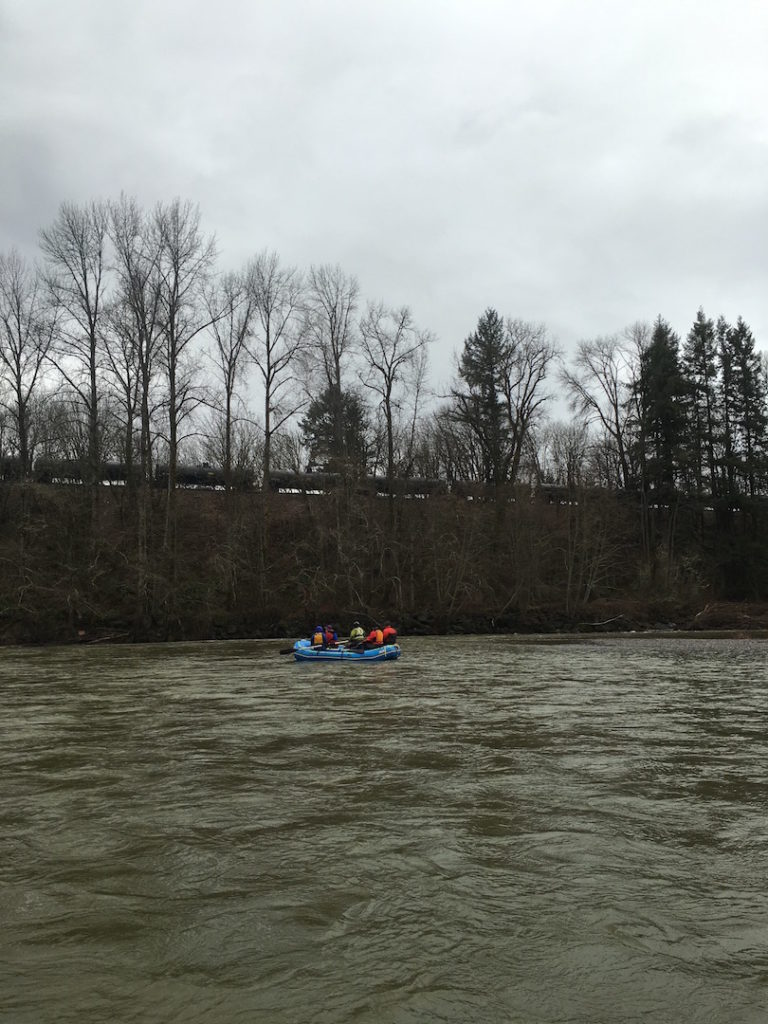
The 6th Avenue take-out/fishing pier is around the bend, once the river floats parallel to the train tracks.
Put-in at Nisqually Park at Yelm Powerhouse (river left, approx. River Mile 12.5), which is owned and operated by the City of Centralia.
Address: 14024 Yelm Hwy SE, Yelm WA, 98597
Contact: 360-458-3901 or 360-888-2617 (after hours)
Hours: 7:00 am – 8:00 pm (Note: Hours are subject to change. Contact the City of Centralia for the most up-to-date information)
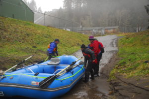
Nisqually Park boat launch. Photo: Thomas O’Keefe
- The park has a paved boat launch, well maintained portable toilets, a picnic table and on-site parking
- This site sees moderate use throughout the year, with peak visitation in May-August. Be prepared to share the launch with others!
Take-out at the 6th Avenue Handicap Fishing Pier, which is owned and operated by Washington Department of Fish and Wildlife (WDFW). It is on river left at approx. River Mile 4. A Discover Pass is required for all vehicles parked on site.
Address: 11642 6th Ave SE, Olympia WA, 98513
Contact: 360-902-2200
Hours: 4:00 am – 10:00 pm (Note – Hours are subject to change. Contact WDFW for the most up-to-date information)
- The park has a restroom and fishing pier. There is not a developed boat launch, so canoes, kayaks or rafts must be carried from vehicles to the water.
- A significant amount of wood and other debris can accumulate against the bank, limiting the areas that are appropriate and safe for boats to use.
- This site is well used by fishermen and other recreationists year-round. Keep an eye out for fishing line and be prepared to share the space.
- Beyond the railroad bridge is private property. Be sure to stay on the downstream side of the bridge.
Joint Base Lewis-McChord’s Tank Bridge is an undeveloped launching point to the river. Users must
The undeveloped put-in/take-out area. Stay on the downstream side of the bridge
obtain a range access pass through JBLM prior to access, and follow all additional regulations. The access site is on the downstream side of the bridge on river left at approx. river mile 11.5.
Hazards & Safety Information
*Note: This is not an exhaustive list! River conditions can change very rapidly. New hazards may appear at any moment.
- Before going on any river, be sure to take steps to increase personal responsibility, boat safety, the preparedness of your group and to understand water rescue principles. American Whitewater has a comprehensive list of actions that all river users should take to increase their safety. Make sure you and everyone in your boating party follows these guidelines!
- Always wear a lifejacket and helmet and bring proper gear for weather conditions. Always carry a first aid kit.
- The Nisqually River has cold and swift water, poor water visibility, log jams, boulder gardens, and other natural hazards that are subject to change. These hazards can quickly turn lethal if users are unprepared. Among other things, hypothermia can set in within minutes if exposed to water.
- This section of river has a history of containing very large log jams. These log jams can change in an instant. It is sometimes necessary to portage around these log jams, which can prove fatal if anyone becomes trapped.
- Most of the land on either side of the river in this stretch is in private property and are not appropriate landing spots. In particular, Joint Base Lewis-McChord and the Nisqually Indian Reservation are not open to public use. JBLM lands may feature unexploded ordinances or other hazardous materials and should be avoided.
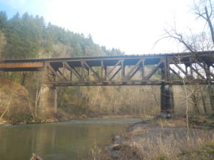
- On this stretch of river, boaters must cross under multiple bridges and railroad trestles. The piers and abutments in the river pose a significant hazard to users. Depending on river flows and past flooding, these abutments can collect logs, uprooted trees, branches and other debris at their base, often directly in the main current of the river. These obstacles can be fatal if users are unable to maneuver around them.
- Check flow conditions as seasonal rapids or mudflats may appear depending on water levels.
Map
This map and guide is available for print from this website. Download a PDF version to print here. Please note that this map is only a rough guideline of known hazards, and water conditions can change at any time. You are responsible for your own safety.
Leave No Trace
Leave No Trace is built on seven core principles that are used to communicate the best available minimum impact guidance for enjoying the outdoors responsibly:
- Plan ahead and prepare
- Camp and travel on durable surfaces
- Dispose of waste properly
- Leave what you find
- Minimize campfire impacts
- Respect wildlife
- Be considerate of other visitors
Please help keep the Nisqually beautiful and healthy by practicing these principles whenever you go exploring!
Risk Disclaimer
The Nisqually River is dynamic and river conditions and hazards can change at any time. Please use at your own risk. This river can be technical and under many conditions may be dangerous to float and may involve the risk of property damage, serious injury, and possible death. It is your personal responsibility to be prepared with the right equipment and training and to not paddle above your technical ability level, use common sense, and obey all rules. Flow and up-to-date information from American Whitewater: https://www.americanwhitewater.org/content/River/state-summary/state/WA/